NASA Captures Images Of Flooded Areas In UAE After 6 Billion Cubic Meters Of Torrential Rain; KNOW MORE About It
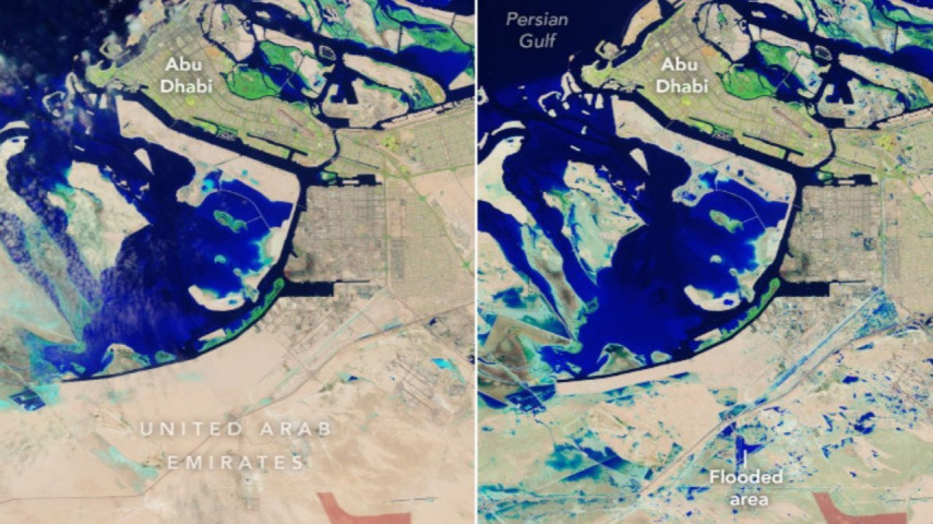
NASA has revealed images of the aftermath of the UAE flooding due to torrential rain. Their Landsat 9 satellite has successfully captured images that show severity and hint at drastic weather changes.

-
NASA's Landsat 9 satellite captures flooding aftermath in the UAE
-
Climate change exacerbates extreme weather events
Last week, the UAE encountered its worst flooding ever when an unusual storm system entered the atmosphere, according to photographs made public by NASA. This inundation called a ‘slow-moving storm,’ affected different parts of the UAE and poured down more water than would normally be expected in a year all over this area.
On April 19, 2024, pictures taken from space by NASA’s Landsat 9 satellite showed flooded areas, particularly Jebel Ali. These images depict how severe the flooding was and what difficulties people living in these regions went through.
Before and after: A tale of transformation
A combination picture put up by NASA makes remarkable contrasts between before and after heavy rain. The UAE on April 3 versus April 19 reveals two different states of affairs regarding geography; the first photo exhibits dry plains typical for this region, while the other one indicates massive blue pools mainly located in southern areas.
According to Khaleej Times, key infrastructure, including Sheikh Zayed Road, which connects Dubai with Abu Dhabi, has suffered due to flooding. Furthermore, residential areas like Khalifa City and Zayed City, located southeast of Abu Dhabi’s center, were also flooded, making life tough for inhabitants.
Dubai bore the majority brunt since most private sector firms adopted working-from-home policies during that time. Inundations that lasted several days hampered rescue interventions in the desert country because roads were covered with water throughout this period.

Climate change's role
These rainfall intensity levels, together with their resultant floods, have been identified as manifestations of climate change that remind us about what the UAE needs and indeed still needs to do about global warming problems.
With the increasing frequency of extreme weather events, such as stronger storms like hurricanes, nations should, therefore, enhance their resilience measures to minimize harms arising from global warming.
Pumping trucks with giant hoses were brought in by the city administration since the drainage systems are not sufficient. These attempts stress the need for better preparedness and adaptation to future weather uncertainties.
The recent floods have served as a be-all and end-all for the interconnections of climate change patterns worldwide, which calls for concerted action to save vulnerable communities from the impacts of climate change.
In the face of extreme weather events, collaboration, innovation, and resilience should drive nations as they strive to build a sustainable and climate-proof future.
ALSO READ: Charity boss steals GBP 18,000; Funds bingo habit with donated money


 JOIN OUR WHATSAPP CHANNEL


